Trail Walking La Tronche - Mont Jalla - Photo
 ranchoup
ranchoup

User

© OpenStreetMap contributors
Length
Length
8.1 km
Max alt
Max alt
636 m
Uphill gradient
Uphill gradient
484 m
Km-Effort
Km-Effort  
14.5 km
Min alt
Min alt
241 m
Downhill gradient
Downhill gradient
486 m
Boucle
Boucle
Yes
Creation date :
2020-09-26 08:07:47.474
Updated on :
2020-09-26 13:05:10.053

(0 Reviews)

Walking
Walking
2h56
Difficulty : Easy

Scan this QR Code to open this trail in the SityTrail application

FREE GPS app for hiking

Logo SityTrail SityTrail

IGN / Geographical institutes

Download SityTrail from the App Store Download SityTrail from Google Play

Logo SityTrail SityTrail Plus

The world is yours!

Download SityTrail from the App Store Download SityTrail from Google Play Download SityTrail on Huawei AppGallery

About

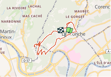
Trail Walking of 8.1 km to be discovered at Auvergne-Rhône-Alpes, Isère, La Tronche. This trail is proposed by ranchoup.

Description

Boucle à faire pour un plan B,  mais très fréquentée par les joggeurs le we.
Chemin un peu trop raide sur le tronçon Bec de Corbeau-Noyarey. (et pourtant c'est un tronçon GR).
Faire le petit crochet jusqu'à la petite chapelle de la Vierge Noire (située à coté d'une maison au lieut-dit la Pinotte.
Beaux points de vue sur Grenoble et Belledonne.

Elevation profile

Positioning

Country:
France
Region :
Auvergne-Rhône-Alpes
Department/Province :
Isère
Municipality :
La Tronche
Location:
Unknown
Start:(UTM)
715256 ; 5009670 (31T) N.


Close
My subscriptions